The Yarra River flooded regularly in the early years of European settlement. The first big flood was on Christmas Day in 1839. It rained for three days and nights and what is now Southbank vanished under two metres of water. Brickmakers lost their kilns and huts and a newly erected wharf floated out to sea. Settler, William M'Haffie, later recalled rowing from the Customs House in Flinders Street across South and Port Melbourne to the beach.
The next major flood was in July 1842. Again, the south bank of the Yarra became a waterway with the city reduced to a ‘string of islands’. According to historian, Kristin Otto:
This is when Michael Cashmore undertook his most famous journey: overland by open boat from Footscray to Flinders Street (the Royal Highlander Hotel to be exact) where he and his mates tied up at the bar.
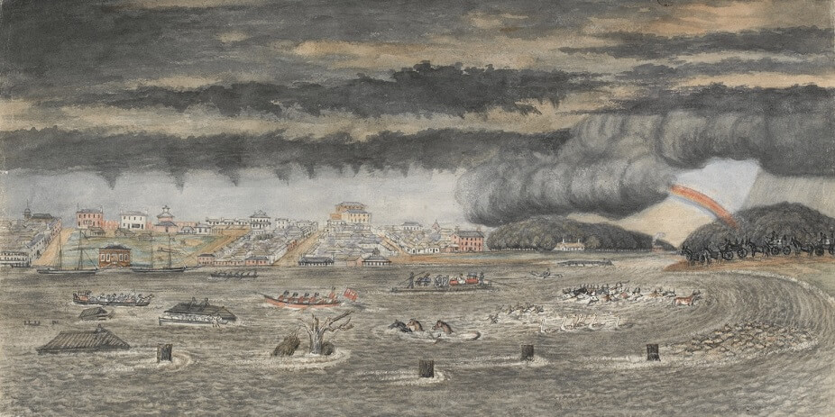
Significant floods occurred again in 1844 and in 1849, when the water at Dights’ Falls rose by 37 feet (11.3 metres). The flood in 1849 created a lake which stretched from Emerald Hill, where the South Melbourne Town Hall is today, to the site of the racecourse at Flemington. St Kilda Road was completely submerged with residents being rescued by boat.
Flooding exceeded previous records in 1863. About 38,000 cubic feet of water rushed past the Botanic Gardens, inundating businesses and residents in low-lying, mostly poor areas adjacent to the river. Melbourne recorded nearly 140mm of rain in five days. One newspaper gave this account:
… the rain poured down in torrents, without an hours intermission… Business in consequence was everywhere suspended, and all interest centred in the rising waters of the river, which presented a spectacle never before witnessed in the metropolis of Victoria.
On the side towards Emerald Hill [South Melbourne] the country was covered to the depth of many feet. The work-shops, dwelling-houses, gardens, and everything else from the Yarra to the rising ground on the further side of the Sandridge Road were inaccessible, except by means of boats. The numerous habitations of shipwrights, smiths, watermen, and others were in some cases completely destroyed, and in all instances greatly damaged, and it was not without great risk that their wives and children were removed to places of safety…
The St. Kilda and Brighton suburbs suffered very much. The water covered the Esplanade at St. Kilda and… the Brighton and Hawthorn trains ceased running because the cuttings were filled with water. At Richmond the flood rose 10 feet. At Hawthorn Bridge the water was 3 feet above the level of the old Bridge road… In this neighbourhood two fatal accidents are reported. About two p.m., a bricklayer, endeavouring to snatch some articles of furniture from the water lost his balance and fell into the current. It was thought he might have gained the opposite bank, as he was reputed a good swimmer, but two hours after nothing was heard of him… another man, named William Bush, a candlemaker, seeing a door floating past, attempted to secure it, but missed his footing and, it is supposed, fell into one of the numerous brick holes, thereabouts, and was drowned.
Many houses are covered along the Yarra banks; and the owners of tan yards and the fellmongers have sustained heavy losses, not only by the destruction of their buildings and fittings, but by the washing away of skins and materials.
The flood of 1849, by artist W.F.E. Liardet. Shows the Yarra River in flood, with boats and sailing ships, horses, cattle, sheep and birds in the floodwater.
Reproduced courtesy State Library Victoria
The ‘Great Flood’ of Melbourne
At daylight the riverside districts of the city presented an appalling sight. From Princes Bridge for several miles upwards the Yarra resembled an inland lake, spreading out into innumerable lagoons to right and left.
Argus, 14 July 1891
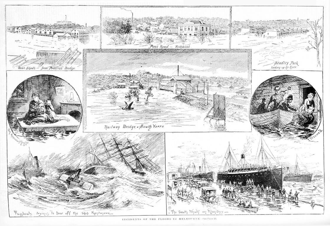
In 1891 the Yarra flooded again, swamping the low-lying suburbs of Collingwood, Richmond, South Yarra and South Melbourne. Referred to at the time as the ‘Great Flood’, as many as 3,000 people were made homeless and three people died. The Bendigo Independent reported:
The water… had crept into scores of houses and factories which the previous night seemed to be out of danger. Residents of Toorak on the river side looked out at breakfast upon a great expanse of water…
At South Yarra the back waters formed a great serpentine lagoon, stretching away from the railway bridge and across Church street and Toorak road to the gully below Chapel street. Toorak road was covered by water for fully a third of a mile and in many of the streets on the Richmond side of that thoroughfare only the roofs of the houses could be seen.
The lower part of Richmond fared no better, Punt road being flooded for a great distance, together with the adjacent streets. The water extended past the Punt road railway bridge near the Richmond station, and was many feet deep in the ground floors of many houses in that locality, the front fences in some cases being out of sight. A great waste of water spread itself between Punt road and Prince’s bridge, extending from the Botanical gardens on the one side to the railway line on the other… The boatsheds on the south bank stood out almost in midstream…
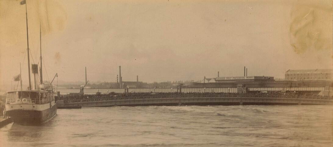
Great flood of July 1891, at Queen’s Bridge.
Reproduced courtesy State Library Victoria
A crowd of people gathered on Queen’s Bridge, looking at the rising flood waters.
The fine weather enabled crowds of people to watch the progress of the flood… Both Prince’s bridge and Queen’s bridge were thronged with onlookers.
Bendigo Independent, 15 July 1891
1934
Though not the largest flood, 1934 probably had the greatest impact because of the number of people and buildings affected. Every creek and river in Melbourne broke its bank, and the Yarra recorded its highest flow, nearly 97,000 million litres in one day.
Kristin Otto, Yarra: A diverting history of Melbourne’s murky river, p.77
The floods in 1934 caused massive damage. In just 48 hours, more than 140mm of rain fell over Melbourne and 350mm fell in South Gippsland. Hundreds of buildings were damaged, 6,000 people made homeless and at least a dozen people died.
The Argus reported:
From Warburton to Melbourne the Yarra has become a series of vast lakes connected by whirling rapids. Boats and boathouses, including those of Scotch and Xavier Colleges, have disappeared; the Heidelberg gasworks have been flooded; and great damage has been done to farms and orchards. Much splendid rescue work has been performed.
See footage of the 1934 flood below. Taken from near Scotch College in Hawthorn.
Flood mitigation
From the late 1870s major engineering works were underway to ‘tame the river’. In 1878 British engineer, Sir John Coode, suggested dredging and the removal of reefs (notably the ‘Falls’ at the present Queen’s Bridge site). He also recommended the cutting of a channel to shorten the river's erratic course at Fishermans Bend. Work began on this in 1880.
Two wide bends in the river’s course near the Botanic Gardens were removed in the late-nineteenth century, allowing floodwaters to move to the bay more readily.
In about 1924 the Melbourne and Metropolitan Board of Works began a de-snagging program, removing dead and collapsed trees from the river to speed the flow of flood waters.
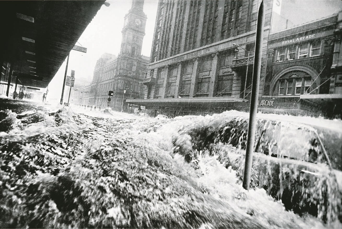
In 1972, 75mm of rain fell on Melbourne over a short period sending waves of water down Elizabeth St. This photograph was captured by Walkley Award-winning Age photographer, Neville Bowler.
Reproduced courtesy The Age newspaper
Sources:
Kristin Otto, Yarra: A diverting history of Melbourne’s murky river, The Text Publishing Company, Melbourne, 2005.
Next: Enjoying the River


